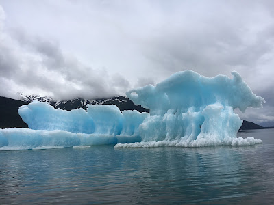
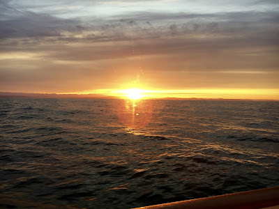
We have just finished our second extended cruise that started from our homeport of Salpare Bay Marina in Portland, Oregon. After traveling west on the Columbia River, we traveled north 15 miles off the Washington coast, through Pugent Sound, up through the inside passage of Canada, as far north as you can go in SE Alaska before turning around and heading south, ultimately returning to our homeport 166 days later.
 |
| Before.... |
 |
| .....and during a calving event. We got the trawler tender in reverse immediately! |
You can read all the books, tech manuals, instruction books, discussions on forums and picking the brains of all those that have done extended cruises before, however, until you do a cruise of this distance and time, you have no idea what it takes. Yet, we met so many people that do this type of cruise year after year.
 |
| Our 62 pound halibut, caught in Icy Strait of Sisters Islands. |
We would like to send a BIG THANK YOU to all the people we met who impacted our adventure. If your name and/or boat are not listed below, please let us know, because without you, this trip would not have been so enjoyable.
Tom and Kay Teseniar, M/V Alaskan Sea-Duction, Camarge 48,
Al and Carol Johnson, (Ketchican AL)
Jeff Merrill, our broker and good friend, jmys.com
Larry and Marcia Crass, M/V Hale Kia, Nordhavn 43,
Bill and Wendy Brown, Sea Badger, Selene 4314,
Eric and Kim Rimkus, S/V Gladiator, Beneteau 46
John and Cindy Hanson, M/V Lucky Girl, Selene 37
Russ and Missie Low, M/V Melissa Lynn, Selene 53
Dean and Teresa Klein, M/V Salt Heart, Selene 62
Rick and Pam Panowcz, M/V Jean Marie ,Selene 47
Kevin and Alison Jefferies, M/V Red Rover, Nordhavn 55
Walt and Joan Vennemeyers, M/V Manatee
Vaughan and Rita Balaam, S/V Baraka Bashad
Ken, M/V Hat Trick, Hatteras
Tom and Nita Sitterly, M/V Cygnus Argent, Ocean Alexender
Jerry and Suhwa Tompsett, S/V Calypso
Days we traveled 166
Number of ports visited 71
Nautical miles traveled 3,452
Statue miles 3,953
Gallons of diesel fuel 1,854
Fuel burn rate gallons 3.06 includes generator and heater
Main engine hours 606
Generator hours 565
Days at anchor 53
Days in moorage 113
Days buddy boating 116
Publications
We used several publications in order to plan, track and gather information throughout this trip. I’m sure that other publications are available, however these were the ones we focused on to help insure a favorable experience. By far the Waggoner Guide was the publication that we used the most for Canada and Exploring S.E. Alaska for navigating Alaska. We purchased many publications to help us. The ones listed below were used most often.
- Waggoner Cruising Guide by Burrows Bay Associates, WaggonerGuide.com
- The Inside Passage, Route Planning Maps, North and South Portion by Fine Edge
- Broughton Islands Cruising Guide by Peter Vassilopoulos
- Exploring Southeast Alaska by Don Douglass and Reanne Hemingway-Douglas
Navigation
The primary navigation that we used was Navionics on an IPAD. For $50 a year you have a very nice, user friendly, chart program. This became our primary navigation tool. All you need is an IPAD which has built in GPS so as to track your boat. If you choose to go this route, get an IPAD with as much memory as possible! You can store so many charts without internet access. After learning that there was a magnetic disturbance in our compass, causing the auto pilot to fail, we removed the 20 inch monitor mounted on the dash in the pilot house. John built a bracket for our IPAD (out of black starboard) and mounted it where the monitor was. This offered a much more favorable instrument for our charts. FYI, we found we had to cover the IPAD and most other instrumentation with a dish towel or tape to run after dark in order to preserve our night vision.
 |
| Our first overnight run underway 15 miles off shore in the Pacific. |
 |
| A most welcomed sunrise, 24 hours later, in the Strait of Juan de Fuca. |
Docking
Locating moorage in Alaska was much the same as Canada, however, private docks were few and far between. Most of our time in Alaska was at anchor or in a public harbor. When possible, we sent an email in advance to reserve a spot. We relied on the VHF to radio ahead most of the time.
There are both state and city entities running the marinas. Some give you slip assignment, others provide transient moorage on a first come first serve basis. Wrangel, AK is an example of that. State run docks, such as Swanson Harbor, are available, but primarily established for the commercial fishermen. We found that as long as your willing to raft to one another, you can use the docks.
Our Alaska marinas and docks...
Ketchikan - South Bar Marina
Juneau - Harris Harbor
Swanson Harbor - Government dock
Hoonah Harbor - Marina
Wrangell - Reliance Harbor
Warm Springs Bay - Government dock
Coffman Cove
Hartley Bay / Gigat't First Nation
Shoal Bay
Port McNeill (Steve Jackson’s)
Sullivan Bay
Lagoon Cove
Port Neville
Gorge Harbor
Shearwater Marina
Comox Valley Harbor Authority
Anchorages
Below are a few of our favorite anchorages;
Alaska;
Vixen Inlet
Thomas Bay
Snug Cove in Gambier Bay
Ell Cove
Red Bluff Bay
Portage Bay
Cannery Cove, in Pybus Bay
Shoal Pass Bay
Walker Cove in Fitzgibbon Bay
Shrimp Bay
Canada;
Lowe Inlet
Pruth Bay
Shoal Bay
Kwatsi Bay / North Broughton
Khutze Inlet / Northern British Columbia
Bottleneck Inlet / Northern British Columbia
Internet and Cell Phone’s
In regards to "staying in touch", "while off the grid" we did much better this year. We changed carriers to Verizon from AT&T. Rates and coverage are so much better and we think Internet access along the BC coast improved since last year. We also had our portable hotspot from Telus and as long as we were close to cell towers, we had internet coverage. We installed a cell phone booster and life was so much nicer and it really extended coverage no matter what device. AT&T is the main player in S.E. Alaska and so once we were away from the main cities internet was pretty much non existent. But we still had Cell and text service. If we were to do Alaska again, we would probably get a temporary AT&T hot spot.
 |
| John was the early bird securing wi-fi service at the happy hour tent of Sullivan Bay. |
We were again disappointed by the marinas that advertised free Wi-Fi, as a general rule, the internet service was at best terrible. For planning purposes, plan on no Internet coverage, If you get it, feel privileged. If you are used to high speed internet service at home, your going be lost with any service you get, just saying.
Stores and Supplies
For the most part, once you travel north of the Georgia Strait, large towns or communities are non existing. Two cities that are on the north end of Vancouver Island are Port McNeill and Port Hardy and they are your last chance for major shopping. Once you head north of Vancouver Island around Cape Caution the population thins out considerable. One exception is Shearwater/ New Bella Bella where you will find small groceries and a chandlery. This is your last chance before Prince Rupert unless you include Kitimat. Again, the key here is preparation. If we didn’t have the Freezer, food storage would have been tough. We did bring the Food Saver and used it extensively. The marinas that have small stores have to ship the supplies in and that can be costly. Also, the locals in these areas know when the shipments are coming in, so fresh produce and perishables go fast. One last note, Alcohol is very expensive in Canada. In some places it is 2-3 times higher than even Washington State. Just be prepared for a bit of sticker shock. Supplies are readily available in Ketchikan, Juneau and Wrangell for S.E. Alaska. Smaller communities such as Hoonah and Coffman Cove are somewhat limited and a bit pricier, but we enjoyed them none the less.
If you need anything shipped into Alaska, we found that Frontier Shipping & Copyworks in Ketchikan was by far the best service. The address is 2417 Tongass ave., Ketchikan AK. 99901 They charge $1.00 per package, and after losing a few packages at USPS in Ketch we decided the “buck” was well worth it. This is where Tom, on Alaskan Sea-Duction, and we on Pairadice had our new windless shipped to.
Customs
 |
| After checking in with customs... sunset docked at Bedwell Harbor off Pender Island, B.C. |
In Closing
We are now, back in Las Vegas where we will spend the winter. The to do list is rather lengthy, with both personal and boat related projects. Our current plans are to cruise the Columbia and Snake River next summer, and prepare Pairadice for our southbound trip to Mexico in 2019.
 |
| John and Tracey on our wedding anniversary, Wednesday November 22, 2017 |
We are now, back in Las Vegas where we will spend the winter. The to do list is rather lengthy, with both personal and boat related projects. Our current plans are to cruise the Columbia and Snake River next summer, and prepare Pairadice for our southbound trip to Mexico in 2019.
Although we have been rather tardy on Blog updates, we are attempting to get caught up. We don't get very much feedback on the blog, and Tracey started a Facebook page which gets a bit more attention. Lack of high speed internet caused us to fall behind on updates.
We are already homesick for the boat and look forward to next summer.
Thank you all for following along, Cheers, All the Best for 2018!


1 comment:
Hello Pairadice, I am a retired Florida boater (48'Sea Ray FB)and just finished reading your "Pendana" interview and emjoyed your story very much. Also found your entire blog to be great reading and hope you will continue as you go forward in your travels. I especially loved your photography I really love your subjects.
Looking forward to your next cruise, stay safe.
Warmest regards, John Middleton
Post a Comment